Life in Christian County, Kentucky...

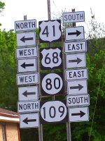
These highway signs are posted at one of Hopkinsville's well known intersections: the corner of Walnut Street and East 9th. This 3-sided intersection could also be called the place where 41-A begins and heads south. Or it could be called the intersection of 41-A with any or all of the highways that are listed above.
This should help Limey (a former resident of Hopkinsville who has returned to his land of birth, England) refresh his memory. He's coming to Hoptown for a visit soon. :)
A road map of Christian County looks a little like a child's drawing of the sun. The round body of the sun is Hopkinsville, and the rays of the sun are all the little roads out from Hopkinsville into the various parts of the county. Or, you could think of the old center of Hopkinsville as the hub of a wheel with many spokes (roads) radiating out from it.
Technorati tags: signs Hopkinsville, Kentucky Hopkinsville
6 comments:
Down the road here in the northern part of Middle Tennessee, we have 31W and 31E, that have nothing to do with west or east. Must just be the part of the charm of this part of the south. :)
Peace,
WIP (wife of RunawayImagination)
Haha. Well, actually it's a test. :D Looks like you passed it!
What a great picture! I am new to Hopkinsville and still trying to figure out the roads. This picture reassures me. Maybe there is a good reason why it is taking me so long!
The layout of the streets in Hopkinsville can be confusing. For the most part, there was apparently no planning. There were just these roads that led into town from all directions, and little by little, the areas between the roads became populated.
I carried a map of the city in the car for a long time after we moved here. Actually, I still keep one there but I just use it for garage sales, nowadays.
I think you can get a free map of the city at the Chamber of Commerce office. The Chamber office is on Fort Campbell Blvd. between Skyline Drive (Holiday Inn) and Country Club Lane (Heritage Bank and the building demolition site.) It's near the Bank of Cadiz.
I love to look at the Yahoo map pictures of Hopkinsville on the internet. Then you really get an understanding of how the roads work in Hopkinsville. It took me a long time to learn my way around. Since I only visit every so often, I still get confused! I love the picture of the sign...I know exactly where that thing is!
I expect that Isaac will get lost a few times when he gets his license and starts driving around by himself. :D
Post a Comment