Showing posts with label Pilot Rock. Show all posts

Monday, August 02, 2010

Pilot Rock

Seen from Todd County


Pilot Rock is one of our local landmarks, and I've photographed it from just about every road around here, I think. Coming back from Rattlesnake Road, I stopped along Pilot Rock Road (Highway 508), just east of Pilot Rock in Todd County, to take this photo.  As you may know, Pilot Rock sits on the county line between Christian and Todd Counties.

Pilot Rock looks like a hill in this photo. And it is a hill, but it's also the highest point of both Todd and Christian Counties. It's a knob on an escarpment -- or to describe it as I see it, it's a big rock that juts out of the top of a steep ridge. When I pulled over to take the photo, I was already halfway up the ridge.

Monday, February 01, 2010

Pilot Rock at the Peak of Its Popularity

Preaching and picnics, with a great view


 A winter view of Pilot Rock, 
from its Todd County side

Pilot Rock is a locally famous landmark of Christian County. We (and many other folks who live in this general area) can see it from our house. Pilot Rock is the highest point of both Todd and Christian Counties, and it's visible for miles.

A century ago, a trip to Pilot Rock was a summer day's adventure for Hopkinsville residents. A party of young folks might leave early in the morning in a caravan of buggies or wagons, arrive at Pilot Rock in time for a picnic lunch, enjoy the view for a couple of hours, and arrive back home late in the evening, tired, but thrilled with the natural wonder they had seen.

Preaching at Pilot Rock


Joe Dorris, author of a popular column that ran for years in the Kentucky New Era, once wrote about a letter he had received from Clarence E. Mitcham of Mead, Washington. While visiting Christian County, Mr. Mitcham and his wife had climbed Pilot Rock with an elderly relative and her husband, a Mr. and Mrs. Carpenter.

The climb to the summit of Pilot Rock brought back vivid memories to Mr. Carpenter.

At the peak, Mr. Mitcham writes, Mr. Carpenter told him how Pilot Rock used to be a gathering place for many occasions.

He said he had seen so many persons at the rock that their horses and buggies would be parked around the base in an area covering several acres. The kids would play in and around the rocks. They would have a big dinner there, along with preaching.

Source: "Watching the Parade" by Joe Dorris, Kentucky New Era, October 28, 1969

Here's an example of the sort of preaching that Mr. Carpenter might have remembered. In 1895, the pastor of the Vaughan's Chapel was retiring.  (Vaughn's Chapel was roughly 4 miles southwest of Pilot Rock, cross-country. At that time, it had around 150 members .) "I want to get my congregation as near to Heaven as I can for my last sermon," Reverend Bowles said, (according to Elzie Yancey, who was then a young member of the congregation). And so, the last sermon that Reverend Bowles preached was on top of Pilot Rock. "That rock was crowded with people that Sunday," Yancey said. Fortunately, no one fell off!

The view from Pilot Rock


A fellow named Bill Hubbard lived near Pilot Rock, apparently around 1900. Mr. Hubbard owned a small telescope. He often set it up on top of Pilot Rock and charged a fee to look through it. In those days, most of the visitors hadn't seen a telescope before. They probably didn't know or care that its lens wasn't very powerful. They just marveled at the view. (Source)

"Pilot Rock, A Kentucky Wonder", published in the January 27, 1904, Kentucky New Era, mentions that the smoke of steamboats on the Ohio River could be seen from Pilot Rock with a "field glass". Perhaps the author looked through the enterprising Mr. Hubbard's telescope! The water main in Hopkinsville, 16 miles away, could be seen with the naked eye.

Even today, those who climb Pilot Rock are impressed by the view of the countryside it commands. The view was awe-inspiring, in the days before airplanes and satellites made aerial views common, automobiles and good roads made travel easy and televisions brought the wonders of the world into our living rooms.

Friday, April 27, 2007

Pilot Rock Revisited

Life in Christian County, Kentucky...


Pilot Rock, on the Todd and Christian County line in Kentucky

The folks on the Hoptown Hall Forum have been discussing Pilot Rock lately, and that reminded me that I have a photo of the Rock (above) that I should post. I took it at the end of March, just before the late freeze zapped all the leaves you see on the trees. I like this photo because it suggests how rough the terrain is around Pilot Rock.

Like the images (here and here) that I posted in January, this photo was taken from a gravel road to the northwest of Pilot Rock.

Through the Hoptown Hall discussion of Pilot Rock, I've learned of another treasure legend associated with this landmark. It is similar, but not quite the same as the story I've heard.

I am more inclined to believe the written version (which probably was researched to some extent) than the word-of-mouth version (which was told to me by people who heard it from somebody who heard it from somebody, etc.)

Pilot Rock seen from the southwestThe photo at left was taken about six years ago with a zoom lens from the field just north of our little acreage. This view is from the southwest and I think it was taken in July. That's corn in the background, and I believe it's soybeans in the foreground.

You may wonder why I don't post any photos of the view from Pilot Rock. That's because I've never climbed it! I've never had a desire to stand up there and look off the edge of that rock. I think it would give me the heebie-jeebies.

Our 80-year-old neighbor lady, Miss M., told us about climbing Pilot Rock one Sunday with a group of people when she was a little child. She was wearing shoes with hard, slick leather soles, and she got too close to the edge and began to slip. An adult snatched her back by her skirt-tail just in the nick of time. The Good Lord had other plans for her, Miss M. told us.

Related posts:

Technorati Technorati tags: , , ,

Saturday, January 20, 2007

January Scenes from Christian County, KY

Life in Christian County, Kentucky...


Today I drove the backroads across the northern part of Christian County, or as we call it, "North Christian". As the day progressed, the sky grew steadily grayer, as you'll see in the photos.

Pennyrile State ForestNear the Pennyrile State Forest officesScouts setting up camp

Isaac's troop is having their traditional "freeze-out" camping trip tonight. They're at Pennyrile State Forest. Above, Isaac (red coat) and another scout are setting up their tent. Earlier the forecast called for snow, sleet, and freezing rain tonight, so we weren't sure if they'd sleep in tents or in a building that the Forest Service offered. The weather forecast improved dramatically today, so they're in their tents tonight.


Wall at Pennyrile State ForestOld wall at Pennyrile State ForestWall at Pennyrile State ForestOld wall at Pennyrile State Forest

This old stone wall near the headquarters once enclosed a home and its lawn. Now the home is gone except for its concrete floor and massive stone fireplace, but the wall remains. It stands a couple feet tall and is made from large blocks of native stone. It's capped with a layer of concrete that's shaped like an upside down "V". Small native stones are embedded edge-wise in the concrete.

The old hotel in Crofton, KYThe old Crofton (KY) HotelMain Street at Crofton, KY

Crofton is a little town about 15 miles north of Hopkinsville on Highway 41. The railroad tracks run literally through the middle of town. Trains blocking the crossings are a big problem for Crofton's residents. The Crofton Hotel was built in 1906, and it replaced a former hotel or boarding house that burned down. It closed in 1959. (Source of these historic factoids: Postcard History Series: Hopkinsville by William T. Turner and Donna K. Stone)

Buildings on Main St., Crofton, KYCorner of Main Street, Crofton, KYAbandoned farm buildingsLong-abandoned farm buildings

From Crofton, I went east on Highway 800 and Highway 109. These narrow state highways wind through the hills and valleys, following the path of the old trails. They exist mainly to serve the people who live along them, not for travel across the state.

January fieldsA lush January fieldMore abandoned farm buildingsMore abandoned farm buildings

I don't know why the field above wasn't mowed. I wondered if the land might be owned by a hunting club or group, and maybe they left it for wildlife. I did see a big flock of wild turkeys near here.

Pilot RockPilot Rock seen from the northwestPilot RockAnother view of Pilot Rock
I've written about Pilot Rock several times, and the links to those posts are given below. It stands on the county line between Todd and Christian Counties, and it is the highest part in both counties. This view is from the Ebenezer-Ovil Road, a gravel road that runs between Highway 189 and Highway 508.

Related posts:
Pennyrile State Forest
Pilot Rock
Treasure at Pilot Rock or Apex in Christian County, KY
Seen on Friday, the 13th in which this photo shows the back doors of the old Crofton Hotel.

Wednesday, July 26, 2006

Pilot Rock

Landmark in Todd and Christian counties
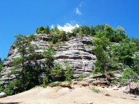


Pilot Rock, Christian County, KYPilot Rock


Pilot Rock is the highest point in both Christian and Todd Counties (in Kentucky) with an elevation of 966 feet. It sits on the county line, at the summit of a large, high hill. It has been cited as a landmark since local history was recorded, and it surely was noted by prehistoric travelers as well.

A Knob on an Escarpment

When I took my brother over to see Pilot Rock, he wondered whether underground activity such as a volcano or a shifting fault line had pushed the big rock upward. I didn't know the answer to that question, and after a little research, my answer is that I still don't know for sure.

The University of Kentucky's Groundwater Resources page for Todd County says that Pilot Rock is a knob on an escarpment. I wasn't entirely clear about what an escarpment was, so I looked it up.

Escarpment or scarp, long cliff, bluff, or steep slope, caused usually by geologic faulting or by erosion of tilted rock layers. An example of a fault scarp is the north face of the San Jacinto Mts. in California. Examples of erosional escarpments include the Palisades along the Hudson River and the long break separating the coastal region from the inland area in Texas, roughly paralleling the coast.

Source: The Columbia Electronic Encyclopedia, Sixth Edition Copyright © 2003, Columbia University Press, as presented by Answers.com

The escarpment in Todd and Christian counties separates the low farmlands of South Christian and SouthTodd from a high plateau in North Christian and North Todd. There are several lesser knobs of note, but the highest of them short of Pilot Rock's elevation by 86 feet:

  • Pine Knob a few miles west of Pilot Rock: 863 feet
  • Keeling Hill in Todd County near Fairview: 848 feet
  • Tucker Ridge a few miles north/northeast of Pilot Rock: 880 feet

Big Clifty Sandstone is the underlying rock of the escarpment. It can be seen at Pilot Rock and on top of other high knobs. It interested me that Big Clifty is also seen on the Mammoth Cave Plateau as the top or "cap" layer of the rock in which Mammoth Cave was carved by underground streams.

Local History

I've read several old histories of Christian County and memoirs of people who grew up here in the 1800's, and without fail, Pilot Rock is mentioned as a recreational site to enjoy.

Of [Todd County's natural objects of peculiar interest,] Pilot Rock is perhaps the most striking. This is a vast mass of rock some 200 feet high, resting upon elevated ground and entirely isolated.

Its summit is a level area of about half an acre in extent, covered with a small growth of timber and wild shrubbery, and is a pleasant resort, frequented by picnic parties from the neighboring country. It stands north of Fairview on the line between Christian and Todd Counties, the larger portion of the rock lying within the limits of the latter.

Its elevated summit, which is gained without much difficulty, affords a fine view of the surrounding country for many. miles, presenting a prospect beautiful and picturesque. In the leafless season and a favoring atmosphere, it is said Hopkinsville, twelve miles away, may be distinctly seen from its summit, and in pioneer days it was known far and wide as an infallible landmark, hence its name.

Quoted from: Kentucky Genealogy. The writing style suggests that this is quoted from an old book, but thus far, I am unable to locate a citation for it.
A few strange events have taken place at Pilot Rock during the time that we've lived here. In one incident, a mentally disturbed person climbed the Rock to elude the police and had to be coaxed down. Another time, a drunk man fell to his death from the summit.

Buzzards at Pilot Rock

Several years ago a girl photographer from the local newspaper climbed Pilot Rock and photographed the fall foliage and autumnal landscape. In her photographic essay, she mentioned big hawks that repeatedly circled the rock. We all laughed, out here close to Pilot Rock. We knew that those big birds were buzzards, not hawks.

A couple of weeks later, the newspaper published a letter from someone in another state who had written to say he suspected that the birds were buzzards, not hawks. We all laughed again.

A lady who grew up in this neighborhood came home to spend a few days. She has lived and worked in the big city for years. While she was here, she decided to climb Pilot Rock for old time's sake.

After her climb, she stopped by the little country store where I was working. Her brother, a local fellow about 50 years old, was there, drinking a soda. She sat down beside him and shared her experience. "It was so peaceful on top of Pilot Rock" she exulted. "I stretched out in the sunshine and just watched the buzzards circling."

Her brother snorted. "I wouldn't be lying on the ground for long if there were buzzards circling over me," he said emphatically. He did have a point, I thought.

Sad Condition

Pilot Rock's listing on the National Register of Historical Places states that Woodland Indians painted petroglyphs on the rock (or somewhere in the immediate area) and used it as a ceremonial site. I have never seen the petroglyphs, but I fear that they may have been vandalized. Pilot Rock is heavily used as a party-place. The ground is littered with broken glass and the sides of the rock have suffered spray-paint graffiti.

I looked at one website that stated that Pilot Rock is privately owned; another stated that the property is owned by "the government" (whatever entity that may be.) I have been told that it was formerly public property but is now privately owned. Whatever is the case, I wish we could take a little better care of it.

Having said that, I'm a little ashamed that I picked up a couple of conglomerate rocks from a washed-out road at the base of Pilot Rock and brought them home to add to my outdoor rock collection! Shame on me for not practicing what I preach. I will restrain myself next time I think of picking up a rock at an unprotected, unattended historic site and natural wonder like Pilot Rock.


Pilot RockMy brother at Pilot Rock Conglomerate rockConglomerate rocks from Pilot Rock


Related site: Todd County High Point Report
Related post: Treasure at Pilot Rock or Apex in Christian County, KY

Sunday, June 04, 2006

Treasure at Pilot Rock or Apex in Christian County, KY

Life in Christian County, Kentucky... History and Old Stuff...


map

I've noticed that several visitors have come to my blog lately, searching for information about the treasure that is supposedly buried in the Pilot Rock area of Christian County, Kentucky.

The treasure is described on Linda Linn's Kentucky Home and Ghost Stories as follows:
Christian County: Lost Treasure
There is a bag with three thousand dollars worth of gold coins buried in the area around Pilot Rock, near the town of Apex.


Folks around here say that the gold coins were payment for a large tobacco harvest that a prominent farmer in the area had sold. On the way home, the farmer and his party were ambushed and attacked, but some of the group eluded the robbers and buried the gold. They planned to retrieve it later, but they could never locate it again.

The distance between Pilot Rock and Apex must be at least 12 miles, maybe 15, as the crow flies. Trails between the two points would have meandered around and through the natural obstructions, so I am amused at the phrase, "in the area around Pilot Rock, near the town of Apex". That's very vague and it encompasses a very large area.

Most of the old trails, except those that have become paved roads or that are still used by farmers, have been abandoned and forgotten. Furthermore, much of the area is rough terrain, covered with trees, rocks, bushes, and poison ivy.

I understand that this treasure is mentioned fairly often in treasure-hunting magazines. And who knows? Someone may find it someday and be a hundred thousand dollars richer. The $3000 in gold coins is said to have appreciated that much in value.

I'd be careful about trespassing over that way. Landowners are sick and tired of meth manufacturers abusing the area, and they might lump treasure hunters into the same category.

Technorati tags:


Related Posts Plugin for WordPress, Blogger...

CONTENTMENT: Keep your heart free from hate, your mind from worry, live simply, expect little, give much, sing often, pray always, forget self, think of others and their feelings, fill your heart with love, scatter sunshine. These are the tried links in the golden chain of contentment.
(Author unknown)

IT IS STILL BEST to be honest and truthful; to make the most of what we have; to be happy with simple pleasure; and to be cheerful and have courage when things go wrong.
(Laura Ingalls Wilder, 1867-1957)

Thanks for reading.