Showing posts with label river town. Show all posts

Thursday, January 19, 2012

Bridges at Cairo, Illinois

Railroads and ferries brought prosperity


A. B. Safford Memorial Museum in Cairo, Illinois, built in 1883

Cairo, Illinois, is at the extreme southern tip of Illinois, at the point where the Ohio and Mississippi Rivers converge.

I always have mixed feelings as I drive through Cairo (pronounced "Care-roh".) Sadly, the town has endured a long period of hard times and population loss. In the business district, empty lots suggest that many deteriorated buildings have been bulldozed and hauled away. Some old buildings, still standing, are candidates for the next demolition list.

I'm not sure if this church is in use.
But the town still has some fabulous old buildings. I always enjoy the architecture when life leads me to Cairo.

Cairo became an important railroad hub after the Civil War, and the town enjoyed several decades of great prosperity. Train cars (and other vehicles) were ferried across the rivers, and the ferry business was as important to local fortunes as the railroad and river-shipping businesses.

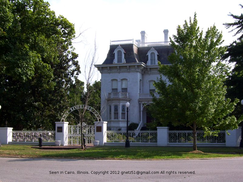
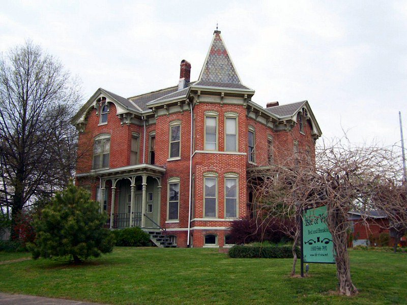
The Riverlore in Cairo, Illinois
During this era, a U.S. Customs House was built in Cairo to process goods from foreign countries.  The Cairo Post Office (a mail distribution center of major national importance) and a Federal court were also located in the Customs House.

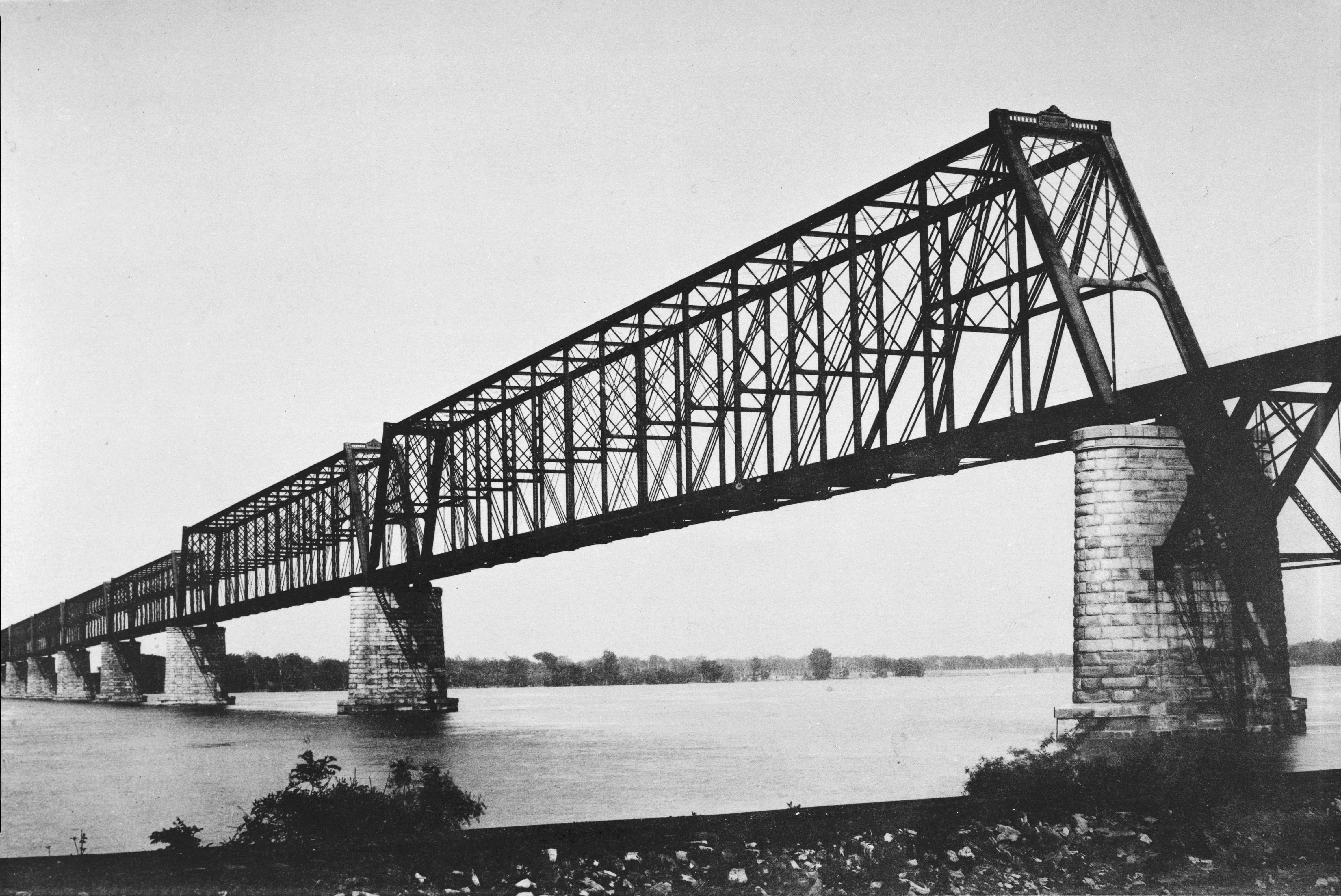
Then in 1889, the Illinois Central Railroad completed the Cairo Rail Bridge across the Ohio River (image, another image). It was a masterpiece of engineering. The metal bridge itself was nearly 2 miles long and the entire structure including the wooden approaches was almost 4 miles long. Freight from Chicago could travel directly to New Orleans via the Cairo Rail Bridge -- a revolution in rail shipping, but a blow to Cairo.

More mansions in Cairo
In 1905, a group of five railroads built the Thebes Rail Bridge over the Mississippi River, eliminating the need for railroad cars to be ferried at Cairo. Thebes, a town on the Mississippi River about 25 miles north of Cairo, was chosen for the bridge because the earth there was much firmer than at Cairo.

Vehicles traveling in the Cairo area still used the ferries until two highway bridges were built -- the Mississippi River bridge (leading to Missouri) in 1929, and the Ohio River bridge (leading to Kentucky) in 1937. The bridges and roads connected a short distance south of Cairo, so travelers could quickly cross both rivers without even entering town.

The loss of the railroad and ferry industries was significant, but it alone did not kill the town. By the early 1900s, other serious problems (racism, corruption, violence, crime) were well-established in Cairo. Over the next century, these evils had a slow-but-deadly effect on the town. You can read about the darker side of Cairo's history at "Cairo, Illinois, Death by Racism."

Overgrowth and disrepair, too!
Last summer, I traveled from Kentucky to Missouri. South of Cairo, I crossed the Ohio River bridge from Kentucky to Illinois, but the Mississippi River bridge south of Cairo was closed for repair. So I drove through Cairo, got on Interstate 57 a few miles north of town, and crossed over the Mississippi River and into Missouri on the I-57 bridge. A few days later, I drove through Cairo again on my way home. That's when I took these pictures.


Related:
A photo I took inside the Customs House some years ago
Seen at Wickliffe, Kentucky

Ohio River bridge, just south of Cairo

Sunday, December 12, 2010

Justice Center and Jail, Hopkinsville, KY

Law and order on the West Bank


Christian County Justice Center, as seen
from the east bank of Little River


Main entrance, Christian County Justice Center
The Christian County Justice Center sits on the west side of Little River in Hopkinsville (KY). This handsome public building was designed by local architect Keith Sharp and put into service in 2002. It includes 73,000 square feet of space and houses five courts.

In a May 24, 2002, Kentucky New Era article, Sharp commented on the underlying philosophy of the building's design:

We live in a land of freedom and justice. You are entering into a place that should evoke you to think about that. Public buildings have a duty to the community to establish a sense of permanence. That sense of establishment is present in this courthouse...
(Source)

Frankly, the Justice Center has so much gravitas that I feel a little awed every time I drive by it.

The Justice Center is connected by tunnel to the Christian County Jail (located on the opposite side of West 7th Street). The jail was also designed by Keith Sharp, and it was completed in 1994. Like the Justice Center, it has an attractive, dignified facade. The City of Hopkinsville website has a good photo of the jail, contributed by Jim Creighton.

I don't often have a reason to visit the Justice Center. Unless I am called again for jury duty, I probably won't go there again until I need my driver's license renewed. I have never yet been inside the jail.

These two "law and order" buildings, the public library, and the public park along Little River form a civic campus that enhances the west side of downtown Hopkinsville. I wish all the approaches to our historic downtown area were as attractive!

West 7th Street, looking toward
Little River and the historic downtown

Wednesday, March 17, 2010

Seen at Golconda, IL

Historic Ohio River town


Last Friday, I took a road trip with my daughter Keely and her fiance Taurus. One of our destinations was Golconda, the little town in southern Illinois where Taurus grew up. Golconda is located on the Ohio River, about 20 miles across the map (36 highway miles) northeast from Paducah, KY.

Saturday, March 06, 2010

Eddyville: River Town

How Eddyville, KY, got its name


I came across some interesting information about the little town of Eddyville, KY, recently. To give this historic trivia some context, I must explain that Eddyville was a village on the Cumberland River. I use the past tense because the Cumberland River at Eddyville is now Lake Barkley. Most of old Eddyville-on-the-river is now underwater. Some of the concrete foundations and streets are still visible under the water and at the edge of the lake.

Eddyville today is located on higher ground near the lake. You can read a short history of the relocation of this Lyon County village at the "Explore Kentucky Lake" website. To this day, many in this part of Kentucky harbor hard feelings about the land the Federal government confiscated to make Kentucky Lake, Lake Barkley, and Land Between the Lakes.  And there were other Federal land grabs around here too -- but that's another post.

Long before Lake Barkley came to be, Eddyville was a village beside the Cumberland River, at the mouth of Eddy Creek, two days downstream from Nashville, Tennessee. Eddyville was the last important river port of the Cumberland. From Eddyville, it was only 45 river miles to Smithland where the Cumberland flowed into the Ohio River.  It was established in 1798, and by 1800, it already had a population of 69.

And now at last, I'm ready to pass along the bit of historic trivia that I promised -- the reason for the town's name. This would have been clearly evident at one time, but the lake has changed everything.

The Cumberland River, when it took its natural course, had two large eddies near the little settlement named Eddyville. Eddies are strong currents in the river that flow backwards or in a whirlpool. One of the eddies was below the town  and the other eddy was two miles above the town. A French traveler, Michaux, wrote in his journal in 1795: "Rowed about seven leagues and slept at the Great Eddy, which is considered to be a distance of 45 miles from the mouth (of the Cumberland)." (Source)

I wonder if the eddies would still be there if the lake were drained.

Eddyville was a boat-building village. Matthew Lyon (father of Chittenden Lyon for whom Lyon County was named) was the first of several notable boat-builders. Besides the several gunboats that he built for the U.S. Government, he built a large number of barges and other river craft.  A traveler of the Cumberland River in the early 1800s could stop in Eddyville and buy a boat that was sturdy enough for a trip down the Mississippi River all the way to New Orleans.

Location of Eddyville, KY (map courtesy of Wikipedia)

Thursday, July 30, 2009

Van Buren, Missouri

An interesting Ozark village


I dawdled a little on my way home from Kansas, a few weeks ago. My ten-minute stop at a gas station along the highway turned into a two-hour visit to downtown Van Buren, Missouri.

Let me explain. I've been traveling through southern Missouri for 19 years now, on my way to and from family gatherings. Highway 60 was (and is) the most direct route from Cairo, Illinois, to Springfield, Missouri. When I started driving Highway 60, it had some very narrow, crooked passages through the ridges and valleys of the Ozarks.

Highway 60 to Van Buren


The very worst part of the road was the 25 miles just before Van Buren, Missouri, and the 25 miles just on the other side of Van Buren. Woe to the trucks that were forced to travel that twisting snake of a road. Woe to the cars that were trapped behind the trucks. Woe to the children trapped in the back seats -- especially those who suffered from car-sickness -- and woe to their parents.

Because I remember the old road vividly, I appreciate the new 4-lane road that leads into Van Buren from the east. The road through the most mountainous area west of Van Buren is now 3-lane, and it will soon be 4-lane, too. The taxpayers of Missouri (and I suppose, the entire nation, through Federal highway grants) should be proud of this highway. I'm sure it's been an engineering challenge to build it.

Until the roads were blacktopped and tourists began driving through the Ozarks, most people around Van Buren made a living, one way or another, from the Ozark hills and trees. Country folks grew and made most of what they needed. Van Buren's handful of stores supplied the rest of what people had to have. A trip to Poplar Bluff or Springfield would have been a rare adventure in a big city.

I saw, sensed, and imagined things like this, during my many trips on the treacherous old road to Van Buren. The big new road doesn't inspire nearly as many thoughts of this sort.

A river town


The Current River runs briskly along the west edge of Van Buren, and you can walk right up to the water on either shore. Small watercraft -- flatboats, canoes, and rafts --were once important modes of transportation through the area. The river crossing at Van Buren was valuable property during the Civil War. Several skirmishes occurred in this area between Union and Confederate/guerilla forces. Today, the river is popular again for rafting and canoeing.

Tree covered ridges dominate the skyline at Van Buren. If there are any grain elevators or smokestacks in the little town, I've never noticed them.

The Carter County courthouse, a WPA project and Missouri's only cobblestone courthouse, sits in the center of a well-shaded town square. It is the tallest building in downtown Van Buren and probably the entire town.

The historic marker on the courthouse lawn tells how Carter County's primeval forests were clear-cut around 1900, bringing two decades of boom to the area before the last trees were cut and the sawmills closed. I think that Van Buren is still struggling to overcome that setback. Tourism has helped.

The commercial buildings around the square are modest structures, and the houses along the highway are modest, too. It appears to me that Van Buren has never enjoyed much excess of wealth.

Visits to Van Buren


I've stopped in Van Buren many times and wandered around for a few minutes. My kids will read this and remember photographs of themselves in Van Buren. Sometimes we stopped and walked around the courthouse square, when we were traveling to or from Aunt Charlotte's house.

When I passed through Van Buren most recently, I stopped at the new station along the big new highway for gas and a brief stretch. I intended to get back in the driver's seat and hurry down the road, but nostalgia called me. I decided to drive down to the river and find an interesting rock to take home. It would only take a few minutes, I told myself.

Near the river, on the street that used to be the highway through town, I saw a little sign that said "Hidden Log House Museum". After I had found my rock at the riverside, I decided to see what the museum looked like from the outside. Then I got out of my car to take its picture, and while I was doing that, the lady who owns the museum came outside to talk to me.

I had to go inside. It would have been rude to drive away, and the admission was only $2. Besides, I was curious. It turned out that the little museum was well worth the visit. I've never been disappointed by a stop in Van Buren.

Wednesday, March 04, 2009

Nine Historic Homes in Henderson, Kentucky

A few photographs of Henderson's historic residential district


I took these photos of handsome old homes in Henderson, KY, when my son Isaac and I visited the town last fall. Henderson has a great number of buildings, commercial as well as residential, that date back to the great days of tobacco shipping on the Ohio River.

It was hot on the afternoon we visited Henderson's historic residential district, and my companion was a little impatient. I didn't do the walking tour as I had hoped. Rather, I drove through the district and got out of the car a few times to take photographs of the luxurious homes built in Henderson's past.

It would be better to walk the tour than drive it as I did. It's often difficult to find a parking place, and some of the streets are heavily traveled. I didn't get to find and identify most of the houses and commercial buildings on the tour brochure.

Henderson is an interesting town. We would still have several days of things to see and do if we were to visit again. Maybe we'll go again this spring, with Dennis this time, so we can take him to the LST memorial  just across the river in Evansville, Indiana. Dennis is a Navy veteran, and he would really enjoy touring the ship. I'm planning to post some photos of our visit to the LST later this week.


Related posts:
Folk Masonry Seen in Henderson, KY
Audubon State Park 
Sunset Over the Ohio River

Tuesday, March 03, 2009

Folk Masonry Seen in Henderson, KY

Eccentric brickwork


This modest little house in Henderson, KY, would be quite ordinary if its brickwork ran in straight, horizontal lines. However, as you can see (click the photo for a closer look), the bricks are laid in a very curious way.

The bricks at the corners are set mostly straight and square, but in the rest of the wall, the lines of brick and mortar meander around the stones. It's an interesting example of what I'd call eccentric brickwork or folk masonry.

I saw this little house last fall when my son Isaac and I camped at the Audubon State Park at Henderson for a couple of days. I'm planning to post more of the photos from that little excursion later this week.

Update:
When I got the top photo ready to post, I overlooked the photograph below of a more spectacular example of eccentricity in brick and stonework. As I recall, this home was near the one in the other photo.


Related posts:
Audubon State Park
Sunset Over the Ohio River

Saturday, October 18, 2008

Audubon State Park

Camping at Henderson, KY


Another pleasant outing in the faithful Coleman tent


John James Audubon, noted American ornithologist, lived at Henderson, KY, from 1810-1819. Today, the Audubon State Park preserves some of the old-growth forest where Audubon roamed along the Ohio River, observing the birds and collecting specimens to paint.

Isaac and I camped two nights at Audubon State Park, while we were sightseeing at Henderson, KY, and Evansville, IN, last week. Isaac had just three days free from both work and school. Dennis was still obligated at his job for part of that time, so Isaac and I went by ourselves.

The Audubon State Park campground is near the Ohio River, just off Highway 41 at Henderson. In fact, the traffic on the busy highway is clearly heard at the campground. Nonetheless, it's a beautiful site with tall trees and many squirrels. We were the only tent-campers there, and there were only about half a dozen RVs.

Isaac really likes camping, and Boy Scouts deserves the credit for it. I'm glad that he has a wholesome hobby that he can pursue all his life. When I camp with him, we don't rough it too much. We get a site with electricity so we can hang the "trouble light" in the tent for reading after dark.

This time, I also brought along a tiny television set, so I could see the McCain vs. Obama debate. To my surprise, half a dozen stations came in clearly with the small antenna. I watched most of the debate while reclining on my air mattress in the tent. Near the end, rain began falling, so it seemed prudent to unplug the extension cord and listen to my little radio instead.

Our campsite was under several black walnut trees. We set up the tent at the edge of the walnut area, but we still had to clear a spot by kicking dozens of black walnuts out of the way.

Whenever the squirrels ran through the treetops, the walnuts rained down. We weren't hit by any of them, but one did fall on my car's hood so hard that it made a little chip in the paint. Oh, well. That's a hazard of parking near walnut trees this time of the year.

The museum in the park has some of the Audubon sketch books, original paintings, and early prints. It's quite interesting. I didn't take any photos because there's a sign at the museum entrance that says, "No Cameras."

One interesting thing I learned at the museum was that Audubon set very high standards for himself. He went through his work every year on his birthday and destroyed everything that was not up to his current level of painting skill.

Like every other Kentucky state park I've visited, much of the infrastructure at Audubon State Park was put in place by CCC and WPA workers. The museum (photo below) was built in 1938 as a WPA project.

Next time we camp at Audubon, I want to hike some of the trails to see more of the forest. This park deserves more time than we were able to give it on this trip.

Friday, October 17, 2008

Sunset over the Ohio River

A mighty river


Isaac and I enjoyed seeing the Ohio River at Henderson, KY, and again at Evansville, Indiana. We saw this beautiful sunset from a nice park on the riverfront in Henderson.  It has many inviting benches, where you can rest and enjoy the view.

Several of the benches were occupied by groups of men who were chatting and watching the river. A few other people sat alone in the park.

A few blocks east of here, a wide, long, steep street leads right down into the water. It's a public access area to the river where anyone can put a boat into the water. It has parking spaces on both sides of it, so we drove about halfway down to the water and parked. It felt strange; we discussed whether cars ever tipped over sideways and rolled into the river. (Probably not.)

We got out and walked around briefly, but didn't loiter. We felt much safer on the high bank, above the river where the buildings sit, than on a steep downhill slope ending in water. Landlubbers like us have great respect for big rivers like this.

Friday, October 10, 2008

Seen at Wickliffe, KY

River town on the Mississippi


When I drive out to southwest Missouri to see my sister, I always go through Wickliffe, KY, a small town in extreme northwestern Kentucky. Wickliffe sets just south of the confluence of the Ohio and Mississippi Rivers. About four miles north of Wickliffe, I cross the Ohio River. Then I drive through Illinois for maybe a mile before I cross the Mississippi River into Missouri.  It's an interesting bit of geography.

I've always thought Wickliffe is a pretty little town, so I stopped to stretch my legs and take a few photos when I went through there last week.

Five (or more) highways come into Wickliffe from various directions. Several of them go through Wickliffe's business district on the town's main street, 4th Street.

The courthouse is the most imposing structure in Wickliffe. It borders 4th Street on its west side. The only stoplight in downtown Wickliffe is at the southwest corner of the courthouse block, where Highways 62/51 and 286 intersect.

The courthouse doors on the west (photo above) and south sides of the courthouse aren't used anymore. Signs direct visitors to a door on another side. I figured those doors were closed to discourage people from walking across the busy highway like I did.

Wickliffe became the county seat after the original Ballard County courthouse, located in Blandville, burned in 1880. The election results were appealed by Blandville, but Wickliffe prevailed. A second election favored Wickliffe as well, and the courthouse was built. Amazingly, the population of Ballard County at that time was over 14,000, roughly double the current population.

The Mississippi River runs along the west side of Wickliffe. At the riverside, big transport trucks were waiting to pick up loads from barges. Train tracks run along the river as well. The river, the highways, and the trains have been an important influence on Wickliffe's economy through the years.

A couple blocks above the river, a large old store building is mouldering away. The doors on the left side of the storefront seem to have been for loading in and out.

Across the street nearby, a little fish market was open for business. Farther down, a boat store serves brave mariners of the mighty rivers. At the river's edge, a tugboat was pulled into something that I thought might be a "dry dock" (a term I've heard in association with boat repair.)


In the image below, the bridge across the Mississippi River (from Illinois to Missouri) is visible in the distance. The shoreline at right in the distance is the extreme southern tip of Illinois, and the water flowing in front of it is the Ohio River. This is literally a photo of the Ohio River joining the Mississippi River.


I didn't stop at the Wickliffe Mounds on the north side of town. It is a state historic site where an Indian village was once located. We've visited it before, but a return visit would be nice. I didn't have time for it on this trip, though -- I needed to move on down the road.

Wednesday, May 09, 2007

Arrow Rock National Historic Landmark

Life In Missouri... History and Old Stuff...


View of the Missouri River valley from Arrow Rock bluffThe Missouri River Valley at Arrow Rock

If you pass through central Missouri, try to make time for a stop at the village of Arrow Rock. It's located about 15 miles north of I-70 on Highway 41, northwest of Boonville.

This photo of the Missouri River Valley (above) was taken from the bluff at Arrow Rock in early spring, eight or nine years ago. This bluff was a landmark for Native Americans and for early European travelers. A big spring provided good water for anyone who passed. Native Americans came here to gather flint for arrows (hence the name of Arrow Rock). Lewis and Clark wrote in their diaries about the big bluff and the salt licks nearby.

Arrow Rock was established as a town in 1829, and it rapidly became an important river port as settlement pushed westward. The Santa Fe Trail crossed the Missouri River via the Arrow Rock ferry, and much trade and traffic came to Arrow Rock through this intersection.

After the Civil War, Arrow Rock was bypassed by the railroad and it began to slowly dwindle away. With diminished traffic, trade and population, there was no need for new store buildings or homes. The town became frozen in time.

Arrow Rock today (population: 79)
is a time capsule. Buildings still stand from the 1830's, the town's first decade. Many other buildings in the town were constructed by the mid-19th century. Wooden sidewalks and stone-lined gutters are still part of the infrastructure. The entire town has been declared a National Historic Landmark.

Stone lined gutters at Arrow Rock, MissouriThe hour we spent at Arrow Rock was just enough to tantalize me. I hope I can go back sometime. We were driving to Kansas City to visit my mother-in-law, and we'd been in the car all day. You can see the stress of hard travel on the kids' faces. They weren't as impressed with stone gutters as their mother was.

I remember that I was impressed by the neatness of the village. Every store, every house, every parking lot, and every lawn was manicured. Somehow they had convinced or forced everyone in town to make the place look beautiful.

You can read more about Arrow Rock's history and see some good photos of the old buildings at the Friends of Arrow Rock website.

Technorati Technorati tags: , , , , , ,

Friday, April 07, 2006

Superman's Hometown: Metropolis, Illinois

Life in The Upper South... History and Old Stuff...


Superman outside the Massac County CourthouseSuperman guards the Massac County Courthouse.

We were in Paducah, Kentucky, today and we drove the short distance across the river and up to Metropolis, Illinois, so Isaac could go to the Superman Store. He has been grieving for about a year now that he lost his Superman winter hat that he bought there last time.

Metropolis, Illinois, just north of the Ohio River on Interstate 24, was officially granted the title of "Superman's Hometown" by DC Comics in 1972. They could hardly deny the honor to Metropolis because it is the only city in the US with that name and in the Superman comic books, Clark Kent lived in the city of Metropolis.


The Superman Store at Metropolis, ILThe Superman Store in Metropolis, Illinois.

Inside the Superman StoreInside the Superman Store

When you walk into the Superman Store, you notice immediately that it's very blue inside -- Superman blue, that is. The store is full of Superman memorabilia of all sorts: comic books, posters, costumes, t-shirts, hats, key chains, lunch boxes, dolls, and much, much more. Isaac bought a visor that has a Superman emblem on it.

A Superman Museum adjoins the Superman Store, but it was closed. I have never been in it, but Isaac has, and he says it is chock full of all sorts of Superman memorabilia. The clerk told us that the owner has the largest Superman Collection in the USA and that only a portion of it is on display in the Superman Museum.

Isaac and Clark KentIsaac and mild-mannered Clark Kent

Across the street, a huge Superman stands on the town square, guarding the Masac County Courthouse. The motto on the statue's base, "Truth - Justice - The American Way," is appropriate for a center of local law and justice. Isaac agreed to pose with the big guy. He also posed with Clark Kent but he refused to stand behind the headless cutout of Superman or beside Betty Boop. He was finished with photographic nonsense.

On the opposite side of the courthouse, two of the largest maple trees I've ever seen grow on the lawn. I tried to stretch my arms around the smaller one to estimate its girth, and I am sure it is more than 12 feet around. A small white haired lady who was smoking on the courthouse steps observed my tree-hug without emotion. I'm sure the folks in Metropolis are used to the strange things tourists do.


Entrance to Harrah's Riverboat CasinoRiverboat casino entrance at Metropolis

Harrah's Riverboat Casino is probably a bigger attraction in Metropolis than Superman, sad to say. It has a large facility and extensive parking lots along the Ohio River's banks, a half dozen blocks from the courthouse.

It would be interesting to know how much clear profit from the casino has actually been realized by the city of Metropolis. I suppose it has brought some jobs to the town, but there has surely been a considerable expense in infrastructure and law enforcement as well as a loss of peace and quiet.

Harrahs even has buses that go to various towns (including Hopkinsville) to transport people to the casino. I suspect there's a two-fold motive. It does provide safe transportation to people who have drunk too much, and it also provides a way for people to get to the boat and gamble even if they don't have a vehicle they can drive there.

Bed and Breakfast, Metropolis, ILThe Isle-of-View Bed and Breakfast

Metropolis seems to have an awakening interest in preservation and restoration. As in many towns in this area, some of the biggest old buildings in Metropolis were built between 1885 and 1900. I saw signs in some of their windows that said something about a downtown preservation group. An attractive old home near the river has been made into the Isle-of-View bed-and-breakfast.


Fort Massac State ParkFort Massac State Park

Just a short distance up the river on the outskirts of Metropolis, Fort Massac State Park offers nice picnic and camping facilities. (Bring squirrel proof containers -- the park is full of those little critters.) The reconstructed fort is the jewel of the park and it represents far more history than I can go into here.

If you ever pass through southern Illinois on I-24, I recommend Metropolis as an interesting place to spend a few hours of tourist time. And of course, Paducah, Kentucky is right across the river and it's also an interesting place to visit, so you might want to get a room and spend the night.

------------
UPDATE
------------

I have posted a few more photos from Metropolis.
Related Posts Plugin for WordPress, Blogger...

CONTENTMENT: Keep your heart free from hate, your mind from worry, live simply, expect little, give much, sing often, pray always, forget self, think of others and their feelings, fill your heart with love, scatter sunshine. These are the tried links in the golden chain of contentment.
(Author unknown)

IT IS STILL BEST to be honest and truthful; to make the most of what we have; to be happy with simple pleasure; and to be cheerful and have courage when things go wrong.
(Laura Ingalls Wilder, 1867-1957)

Thanks for reading.